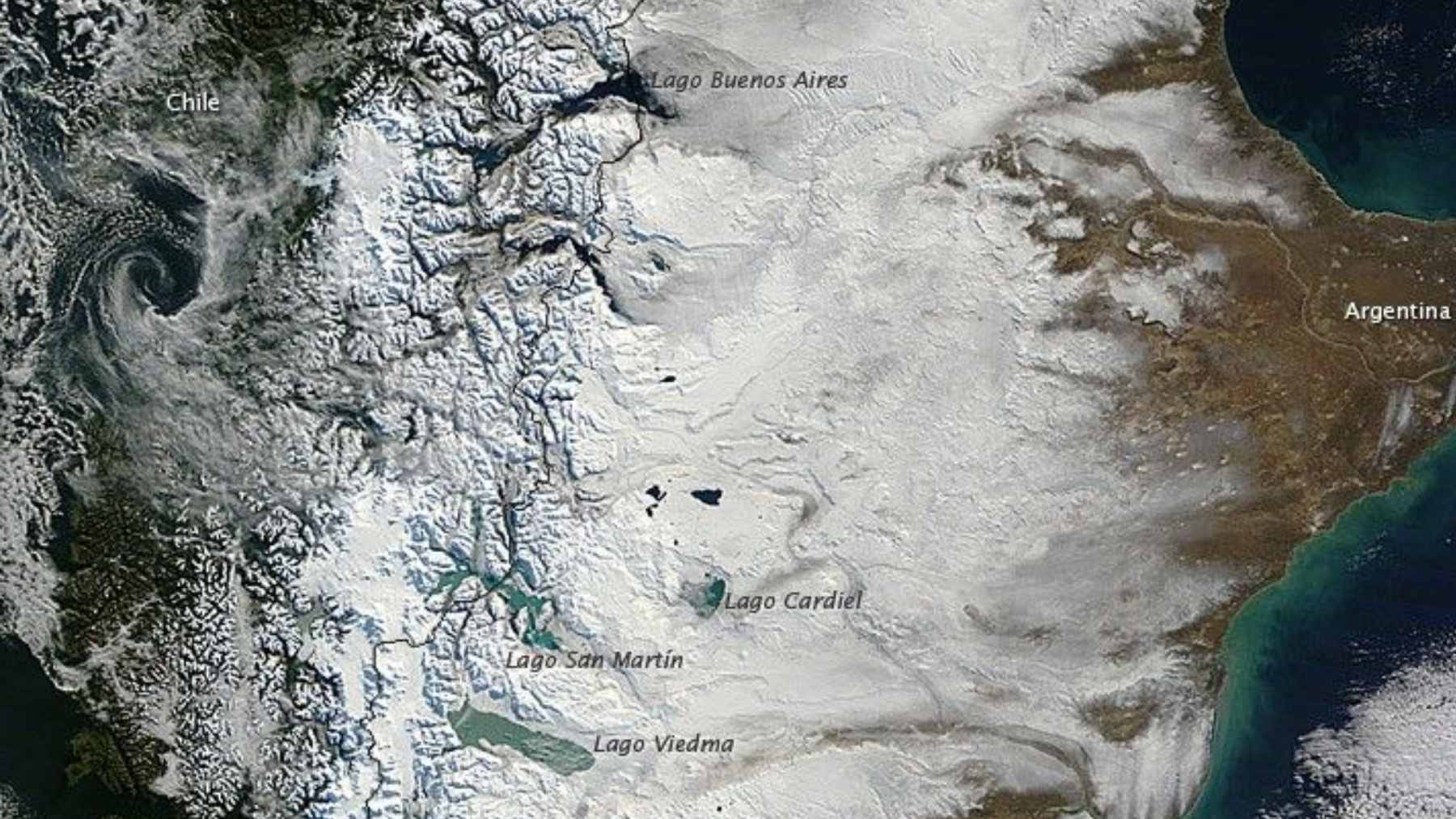
If you’ve scrolled past a new satellite image of southern Chile, you might have done a double take. In a Landsat 9 view from April 12, 2026, parts of the Magallanes region look like the snow itself has turned red. It didn’t, but the illusion is striking.
NASA’s Earth Observatory ties the color shift to a seasonal burst from temperate deciduous forests, not an odd change in the snowpack. That nuance matters because satellite imagery now feeds conservation work, climate planning, and business risk models. When a dramatic frame travels fast, context is the most valuable “sensor” of all.
What NASA actually saw
The image was captured when a break in cloud cover opened a narrow window over Patagonia. Reddish hillsides pop against the usual palette of white mountain snow, brown plains, and blue glacial lakes. For a short stretch of austral autumn, forests add warm tones that can look like “red snow” at a glance.
Those forests are not just scenery. Patagonia holds the southernmost temperate forests on Earth, and NASA notes that southern beech trees (Nothofagus) form the backbone of Andean forests. They can tolerate freezing temperatures and very low rainfall.
The trees behind the color
The main character is the lenga beech, or Nothofagus pumilio. NASA describes it as spanning roughly 2,000 kilometers (about 1,200 miles), from around 36° south latitude down to Tierra del Fuego near 55° south. In many places, lenga is the dominant tree, so when it changes color, whole hillsides flip at once.
This species also draws a sharp line on the map. In warmer parts of its range, lenga can grow around 1,700 meters (about 5,600 feet) above sea level, but farther south it shows up much lower. In the Landsat scene, NASA places the red ridgetops about 100 kilometers (60 miles) northwest of Punta Arenas at roughly 600 meters (2,000 feet).
The tech behind the picture
Landsat 9 is built for repeatable, comparable views, not one-off postcard shots. NASA’s fast facts list a 99-minute orbit and more than 700 images per day, with global land and coastal coverage every 16 days (and an 8-day cadence when paired with Landsat 8). That steady rhythm is what turns a pretty image into a dataset you can test.
The satellite’s sensors explain why it is so useful for environmental monitoring. Landsat 9 carries the Operational Land Imager 2 and the Thermal Infrared Sensor 2, with 30-meter multispectral pixels, a 15-meter panchromatic band, and thermal measurements acquired at 100 meters. Combine visible color with infrared and heat, and forests become measurable systems.
Why this matters for business
For businesses that rely on land, the point is not the color itself but what the timing can reveal. Seasonal vegetation patterns are tracked in satellite records to understand cycles that can affect forestry planning, water expectations, and landscape risk. The U.S. Geological Survey says Landsat data support work in forestry, mapping, and global-change research.
Tourism is part of the story, too, because fall color is an economic event in real places. NASA points to destinations including Torres del Paine and Tierra del Fuego, where southern beeches draw “leaf-peepers” during a brief window of reds and yellows. If you’ve ever planned a trip around peak color, you get it.
A quiet Military and Defense angle
Satellite images are also a form of infrastructure, which makes them security-relevant even when the subject is a forest. The USGS fact sheet notes that Landsat imagery has supported the International Charter “Space and Major Disasters”, aiding emergency response and disaster relief.

In other words, the same land imaging that spots fall colors can also help responders see floodplains, burn scars, and storm impacts.
For defense planners, the lesson is less about Patagonia’s foliage and more about decisions under uncertainty. Earth observation is powerful, but it is easy to misread without local ecology and ground checks, especially in remote regions where clouds and terrain limit what you can see. Open imagery helps multiple teams verify what a picture really shows.
What to watch next in Patagonia
So, should people worry when the “snow” looks red? In this case, NASA’s explanation points to a normal seasonal shift in forest canopy color. The smarter question is whether the timing and intensity of these swings stay consistent over years, because that is where climate signals can show up first.
Landsat helps because it keeps coming back, building a comparable record over decades. The program has delivered repeated global observations for managing Earth’s natural resources since 1972, and Landsat scenes are free through the USGS archive.
The official post was published on NASA Earth Observatory.