Mexico City has lived with sinking ground for generations, but NASA has now put the problem into sharp focus from space.
New preliminary data from NISAR, a joint NASA and Indian Space Research Organisation radar satellite, shows that parts of the capital and its surrounding area sank by more than half an inch (more than 2 centimeters) per month between October 25, 2025, and January 17, 2026.
That may sound small on a ruler. On streets, airport runways, water pipes, homes, and historic buildings, it adds up quickly. NASA says uneven elevation changes have accumulated over decades, fracturing roads, buildings, and water lines in one of the fastest-sinking capitals in the world.
A city built on soft ground
The Mexico City area is home to about 20 million people and sits on an aquifer and the bed of an ancient lake. Extensive groundwater pumping, combined with the weight of urban development, has compacted the sediments beneath the city for more than a century.
But the ground is not simply moving down in one neat, even layer. Some places sink faster than others, which is often what turns a slow environmental problem into cracked pavement, damaged buildings, and broken pipes that residents notice in daily life.
The issue is not new. NASA notes that an engineer first documented the problem in 1925, and by the 1990s and 2000s, parts of the metropolitan area were sinking by about 14 inches (35 centimeters) per year, damaging infrastructure including the city’s Metro system.
NISAR changes the view
NISAR (NASA-ISRO Synthetic Aperture Radar) launched in July 2025 and is now taking that long-running story into a new technological era. Unlike a regular camera, its radar can track subtle movements from orbit even when clouds, rain, or vegetation would block other sensors.
That matters because subsidence is a quiet problem. It does not arrive like a storm, yet it can slowly weaken the systems people depend on every day, from drinking water lines to drainage networks and transportation routes. A city can look normal from the sidewalk while the ground underneath is changing month after month.
The satellite’s L-band radar is designed to detect land sinking and rising, glaciers sliding, and crops growing as it passes over Earth multiple times a month. NASA says NISAR is the first satellite to carry two synthetic aperture radar instruments at different wavelengths, and it monitors Earth’s land and ice surfaces twice every 12 days.

What the new map shows
The new analysis was taken during Mexico City’s dry season. In NASA’s map, the areas sinking by more than half an inch per month appear in dark blue, while some yellow and red areas are likely residual noise that should decrease as the satellite gathers more data.
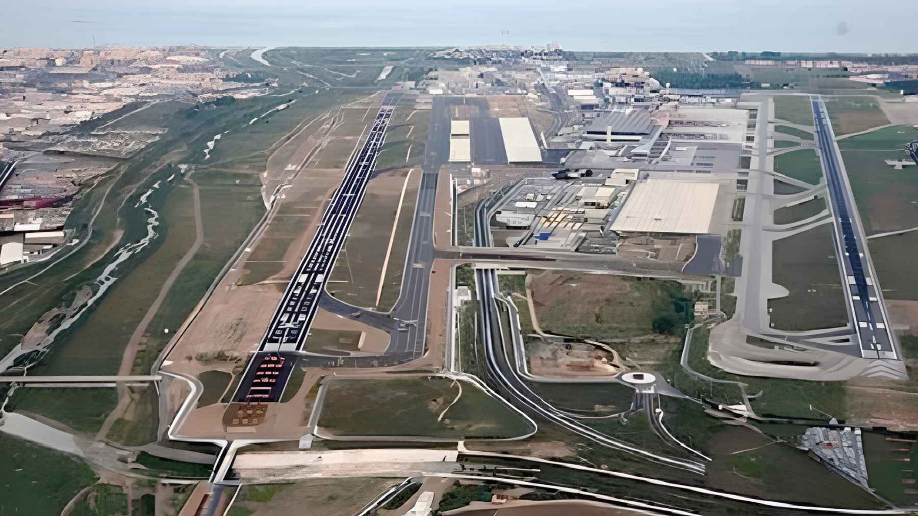
The image also places the problem near critical infrastructure. Benito Juarez International Airport appears close to the center of the map, while Lake Nabor Carrillo shows up as a dark green oblong shape to the northeast.
Why does that matter? Because airports, roads, water systems, and drainage networks do not respond well to uneven ground. A runway, rail line, or pipe can become much harder to maintain when one section sinks faster than the section next to it.
A monument tells the story
One of the clearest symbols of the city’s sinking ground is the Angel of Independence on Paseo de la Reforma. Built in 1910 to mark 100 years of Mexico’s independence, the 114-foot monument has had 14 steps added to its base as the land around it gradually sank.
It is a simple image anyone can understand. You do not need a satellite to notice extra steps at the base of a historic monument, but satellites can now measure the same process across a huge urban area with remarkable detail.
“Images like this confirm that NISAR’s measurements align with expectations,” said Craig Ferguson, deputy project manager at NASA Headquarters in Washington. He added that the satellite’s long-wavelength L-band radar will help track subsidence in harder-to-measure places, including coastal communities facing both sinking land and rising seas.
A warning for other cities
Mexico City is the headline case here, but it is not the only place where groundwater use, heavy development, and climate pressure can collide. At the end of the day, NISAR is not stopping the ground from sinking, it is giving scientists and city officials a sharper compass.
“Mexico City is a well-known hot spot when it comes to subsidence, and images like this are just the beginning for NISAR,” said David Bekaert, a project manager at the Flemish Institute for Technological Research and a member of the NISAR science team.
He said the mission’s global coverage and sensing capabilities could bring “an influx of new discoveries” from around the world.
For Mexico City, the message is direct. The ground is still moving, and now the movement can be watched from space with far greater precision.
The official statement was published on NASA.